

In my January 2016 column, I mistakenly wrote that Burgener Boulevard was named after former U.S. Representative Clair Burgener. Thanks to eagle-eyed readers Adam Chimowicz and Jim Richardson, who each caught the error. The thoroughfare was actually named after the congressman’s brother, Clairemont developer Lou Burgener.
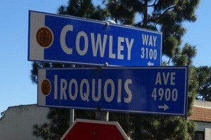
Thanks also to Ruby Konstantin for her fine article about how Cowley Way got its name.
FBI Director J. Edgar Hoover described Samuel P. Cowley as, “the bravest man I have ever known.” In early 1934, Agent Cowley and his fellow G-Men killed John Dillinger, Public Enemy #1, in a hail of gunfire outside the Biograph Theater in Chicago. Later that year, Cowley was killed in a gun battle with notorious gangster George “Baby Face” Nelson. Sam Cowley was the older half-brother of Lou and Clair Burgener and Cowley Way was named in his honor.
Kleefeld Avenue in North Clairemont is named after the 1950s housing developer.
One hundred years ago, brothers-in-law Josephus Asher and Warren Littlefield were real estate developers in Pacific Beach. In 1913, Archer’s Clover Leaf Terrace subdivision opened in Bay Park. Asher and Littlefield Streets remain from that original 1913 Clover Leaf development.
According to a 1947 Bekins Van & Storage Map of San Diego and Vicinity, Littlefield Street in Bay Park turned into Empire Street, which led up the hill to Everview, Bownell and Solar streets. In reality, Everview, Brownell and Solar are actually south of Tecolote Canyon. Empire eventually became a street in Mira Mesa until it was recently renamed AleSmith Court in 2015.
Learning the origin of street names can be a daunting assignment and street maps can be shockingly inaccurate.
A 1926 San Diego Trust & Savings Bank map has some streets northeast of the Balboa and Morena corner which went straight up the bluff. From north to south, they were Linda Vista, El Canto, San Luis Rey and Yorktown Streets. Parallel to Morena Boulevard was Lafayette Street. None of these streets were real. By 1947, nonexistent Linda Vista Street became nonexistent Waterford Street, because Camp Kearny Road was renamed Linda Vista Road during WWII.
Also from the 1926 map is a subdivision that would become known as American Park. Bunker Hill, a short street in Pacific Beach intersected Revere and terminated at U.S. 101 (Interstate 5). It resumed east of Morena Boulevard and proceeded up the hill. Patriotic names like Paul Jones, Ethan Allen, Princeton, Moultrie and Trenton were north/south avenues; Brandywine and Ticonderoga are east/west corridors. Lafayette may have been a Clairemont street for a short period, but Yorktown (Drive) didn’t appear until years later in South San Diego near Imperial Beach.
On December 22, 1903, the Common Council of San Diego ordained the name of Milton Avenue in Logan Heights should be changed to National Avenue. The date is unknown when Milton was rescued from the scrap heap of used street names and given to the original artery that provided access to Clairemont Heights.
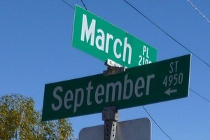
The ’47 Bekins map shows a development at the top of Milton (which became Cloverdale Street) and most of the streets were named after the 12 months. Two exceptions were Arnott and Grandview. There may have been limited construction at that time, but nothing major happened until 1950 when Burgener & Tavares began developing Clairemont.
February, March, July, August and September did become streets. Arnott and Grandview would eventually be used as street names north of July Street. According to the 1947 map, Cowley Way probably should have been June Street.
Many of the oldest streets in Clairemont have Indian names. They are the reason that Clairemont High School athletic teams are known as the Chieftains.
Surprisingly, none of these streets are named for San Diego County tribes (e.g. Cahuilla, Cupeno, Diegueno, Iipay, Inaja, Kumeyaay, Luiseno, Pala, Pauma, Rincon, Sycuan and Viejas).
Some of the existing names are esoteric. Guilitoy Avenue is named after a small Northern California tribe, the Guilitoy, that signed an important peace treaty with California Governor Mariano Vallejo in 1836.
The origin of Jappa Avenue is even more obscure. It appears the Jappa were a band of Cherokee who originally lived near present day Jappa Oaks, North Carolina before they were driven from their homes.
Let’s play the guessing game. How did Neil get a Calle named after him?
We know Cochise, Hiawatha, Pocahonatas and Tonto, but who were Abraham, Anna, Arlene, Barby, Bert, Bertha, Carol, Cecelia, Christine, Della, Diane, Donald, Edwin, Emet, Gaylord, Gertrude, Grace, Henry, Herbert, Hilda, Javier, Jennifer, Jose, Lana, Laurence, Lillian, Lisann, Lloyd, Mabel, Mario, Mark, Martha, Noah, Regina, Roberto, Sandy, Stacy, Tami, Viola, Wayne and Zoe?
(Clue: Abraham, Henry, Herbert and Sandy are mountains; Carol, Laurence and Tami are not.)
The “mount streets” twist and turn across Clairemont Mesa, but nobody seems to know why the developer used mountains for street names.
Why are “ways” in Bay Ho named Plone, Slayen, Stockett, Hunrichs, Nute, Hartman, Conner, Peters and Karnes?
Who were Lehrer (Drive), Morlan (Street), Orten (Street), Rolfe (Road) and Sagasti (Avenue) among others?
The younger generation may shrug, but old-timers chuckle at the mention of Peyton Place.
Apparently Cobb Drive, Cobb Place and Cobb Court were named after San Diego’s first woman city council member Helen Cobb of Clairemont.
Indiana Senator Homer Capehart was instrumental in the passage of legislation that provided housing for military families after WWII. Did the developer name Capehart Street in his honor?
Was Gallatin Way named after Albert Gallatin, Treasury Secretary under Presidents Thomas Jefferson and James Madison?
Is Gesner Street meant to be a tribute to modernist architect Harry Gesner? Or perhaps the Father of Zoology, Swiss botanist Conrad Gessner, AKA: Konrad Gesner?
Aeronca and Bonanza Avenues, Cessna, Mooney and Piper Streets in South Clairemont were named after popular private aircraft from the 1950s. Were the names selected because of their proximity to long-forgotten San Diego Air Park at the top of the hill (the airstrip became Clairemont Drive)?
Permanent street signs for Clairemont were not approved by the city until November 1956. TheClairemont Sentinel reported, “Present signs were erected by the housing contractors. They are of wooden construction and difficult to read.” The new metal signs cost $35 installed.
If you know how your street got its name, please send an e-mail. There are more questions than answers about Clairemont street names. This topic could become the basis for another column of historic trivia, outlandish theories and social commentary.
Email: Bill@Clairemonttimes.com
 Bill Swank outside the Buena Vista Garden Apartments on Cowley Way in 1955 with East Clairemont in the distance.
")

